


Download software tagged by vector graphics
|
The most popular program: Quick Slide Show 2.00

more info |
|
We recommend: Canvas GIS Mapping Edition 9.0.4
more info |
Dino Hard Platformer 4.2 by Falco Software Company
2023-09-05
Dino Hard Platformer - A platform game with nice tabletop graphics and controls. The platform is not quite simple, but somewhat hardcore. But you don't need to rush, simply and carefully go through location by location!
SCP354 Episode 4 8.5 by Falco Software Company
2023-12-30
After a long journey through forests, fields and caves, a special agent finally locates the mystical bloody lake. The game combines the elements of shooter, stealth and puzzle games with great graphics!
Dino Hard Platformer 4.5 by Falco Software Company
2024-02-07
Dino Hard Platformer - A platform game with nice tabletop graphics and controls. The platform is not quite simple, but somewhat hardcore. But you don't need to rush, simply and carefully go through location by location!
Canvas Draw for Mac 2.0.186 by ACD Systems International Inc.
2015-11-26
Canvas Draw for Mac is specifically designed to make it possible for small business owners, designers, illustrators, and professionals to advertise and communicate with confidence.
jalada Collage 2019 19.0.1 by jalada GmbH
2019-05-08
If you want to warm someone's heart, you should give away a handmade gift. jalada Collage offers the ultimate collection for scrapbook pages and other keepsake projects like Christmas, engagement, wedding, anniversary, birthday, Valentine's Day....
jalada Collage for Windows 19.0.0 by jalada GmbH
2019-05-08
Do you want to create a special family presentation with all the kids that you can put on your web site or send to relatives? Or maybe you're a business with a desire to optimize your customer relations with personalized birthday and greetings cards.
Canvas GIS Mapping Edition (Mac) 9.0.4 by ACD Systems
2005-10-26
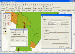
CANVAS 9 GIS Mapping Edition includes direct support for Geographic Information System data. You can take measurements in geographic coordinates, import SHAPE & GeoTIFF files into unlimited numbers of automatically aligned overlapping layers.
Canvas GIS Advanced (Mac) 9.0.4 by ACD Systems
2005-10-26
CANVAS 9 Advanced GIS Mapping Edition: Direct support for Geographic Information System data. You can take measurements in geographic coordinates, import any popular GIS file types into unlimited numbers of automatically aligned overlapping layers.
Canvas GIS Advanced 9.0.4 by ACD Systems
2005-10-26
CANVAS 9 Advanced GIS Mapping Edition includes direct support for Geographic Information System data. Take measurements in geographic coordinates, import any popular GIS file types into unlimited numbers of automatically aligned overlapping layers.