


Download software tagged by free data maps
|
The most popular program: Quick Slide Show 2.00

more info |
|
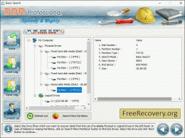
We recommend: Free Recovery 5.3.1.6
more info |
ByebyeData Eraser Free Edtition 1.0.0 by ByebyeData Inc.
2017-07-14
Free hard drive wipe software to clear hard drive and completely delete all files, ByebyeData Eraser Free is the free file eraser to permanently delete files on your hard drive. Besides, you can erase the entire disk or the entire drive.
Google Maps Contact Extractor 2.0.0.0 by Management-Ware Solutions
2016-01-13
Our Google Maps scraper is a versatile, lightweight and powerful Google Maps scraper tools. Google Maps Contact Extractor is a software that extracts information such as business names, address, phone numbers, rating, websites, opening hours, email
AnyMap JS Maps 8.6.0 by AnyChart JavaScript Charts
2019-05-22
AnyMap JS Maps is an advanced JavaScript-HTML5 mapping library with the ever-expanding Map Collection, which makes you able to easily create interactive maps looking great on PCs, Macs, iPhones, iPads, Androids and other devices. Highly customizable.
Google Maps Extractor 7.0.8033 by ScrapMaster Software
2024-03-14
Google Maps Extractor simplifies data retrieval from Google Maps, enabling efficient extraction of valuable information for various needs, from business analysis to location-based marketing
GeoIPTC 1.01 by Soft Experience
2008-01-20
GeoIPTC is a geocoding software service for jpeg and tiff files that provides automatic retrieval coordinates based on photos city IPTC information to locate and display pictures on maps. Works with free Google Maps, Yahoo Maps, Geonames services.
GeoIPTC Geolocalisation de Photos 1.01 by SoftExperience
2008-04-01
Software GeoIPTC by Soft Experience is a geocodding service to edit jpeg and tiff files providing automatic coordinates based on photos city IPTC information to locate and display pictures on maps. Works with free Google Maps, Yahoo Maps, Geonames.
GridImp 2.3 by Winwaed Software Technology LLC
2007-05-06
Imports gridded data into MS-MapPoint, to produce attractive data maps.
Input data is defined with geographic coordinates, allowing plots such as seismic hazard, customer/population distribution, etc. Various text formats and coordinates supported.
GridImp 2.2 by Winwaed Software Technology
2006-08-02
Imports gridded data into MS-MapPoint, to produce attractive data maps.
Can be used to import such attributes as pollution data, seismic hazard, customer/population distribution, etc. Various text formats and coordinates supported.