


Download software tagged by free autocad
|
The most popular program: Quick Slide Show 2.00

more info |
|
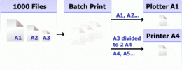
We recommend: 2D Batch Print for AutoCAD DWG, DXF, PLT 1
more info |
Plex.Earth Tools for AutoCAD 1.1.317 by Plexscape.com Environmental Web Services
2009-03-17
AutoCAD plug-in for advanced geographic interaction with Google Earth. Cover large areas with color imagery. Geo-locate site plans. Unique productivity tool with “must-have†features necessary for all engineers and architects.
eBook Creating drawings on a computer in AutoCAD 2007-2008 1.0 by Teachshop.ru
2009-09-20
The book is intended for the development of the graphical system AutoCAD in the study of the course «Engineering and Computer Graphics» engineering professions students and designers.
InnerSoft CAD for AutoCAD 2017 3.8 by InnerSoft CAD
2016-08-05
InnerSoft CAD is a plug-in for AutoCAD that install a set of productivity tools for Civil and Survey, Counting, Estimating, export to MS Excel, import from Excel, measurements in construction project budgets.
InnerSoft CAD for AutoCAD 2016 3.8 by InnerSoft CAD
2016-08-05
InnerSoft CAD is a plug-in for AutoCAD that install a set of productivity tools for Civil and Survey, Counting, Estimating, export to MS Excel, import from Excel, measurements in construction project budgets.
InnerSoft CAD for AutoCAD 2015 3.8 by InnerSoft CAD
2016-08-05
InnerSoft CAD is a plug-in for AutoCAD that install a set of productivity tools for Civil and Survey, Counting, Estimating, export to MS Excel, import from Excel, measurements in construction project budgets.
InnerSoft CAD for AutoCAD 2013 3.8 by InnerSoft CAD
2016-08-05
InnerSoft CAD is a plug-in for AutoCAD that install a set of productivity tools for Civil and Survey, Counting, Estimating, export to MS Excel, import from Excel, measurements in construction project budgets.
InnerSoft CAD for AutoCAD 2012 3.8 by InnerSoft CAD
2016-08-05
InnerSoft CAD is a plug-in for AutoCAD that install a set of productivity tools for Civil and Survey, Counting, Estimating, export to MS Excel, import from Excel, measurements in construction project budgets.
TRIANGULATION for AutoCAD 2.2 by Rcad Software
2019-01-14
An add-on for AUTOCAD, for the TRIANGULATION of a set of point, isolines, KML creator, the VOLUME of a set of 3dface entities, loading of XYZ points files, surface flatness and sections.
LT_SCALE AutoCAD add ons 1.1 by Rcad Software
2019-01-12
LT_SCALE is an add-on for AutoCAD with new commands for scale modification for LINETYPE and HATCH, registration of mileage in BLOCKs, modification of longitudinal profiles, 3D axis and roadside starting from 2D.