


Download GoogleEarthTweaker 1.08
|
Author: ITSTH
Support OS: Win98, WinME, WinNT 4.x, WinXP, Windows2000, Windows2003
File size: 0.3 Mb
Price: 0.00$
Languages: English
Release date: 2007-12-20
Published: 2008-07-21
Support OS: Win98, WinME, WinNT 4.x, WinXP, Windows2000, Windows2003
File size: 0.3 Mb
Price: 0.00$
Languages: English
Release date: 2007-12-20
Published: 2008-07-21
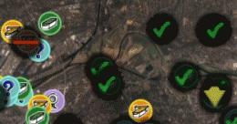
If you use Google Earth to prepare for your Geocaching trips, then you'll know that it's often difficult to find the right caches and to see which ones you already visited. This program makes it easier by preparing your GPX files for Google Earth. Now you can see which caches you've already visited, which ones are out-of-order and which ones you own. Requires GPX files with the cache information.
download
Download free version
Download free version
Related Software
|
We recommend: RoboGEO 2.1
more info |
Earth Satellite 1 by www.satelliteimage-of-my-house.com
2009-04-05
Download the new version of Google Earth with Google Pack.Google pack includes 13 totally free software selected by google for your better internet experience.Software included in google pack - Google Earth, Norton Security Scan, Google Desktop & more.
Uninstall Google Earth 2.1.0 by Uninstall Softwares
2009-04-25
Uninstall Google Earth is similar to Windows Add/Remove program but works much faster and reliable. The advantages of Uninstall Google Earth includes that it's incredibly simple to use and works faster than any other uninstaller.
Using Google Earth to Find Real Estate 1 by www.satelliteimage-of-my-house.com
2009-12-01
Google Earth is one of those cool little tools that, for many, has no use except for visiting places they used to live or have visited before. However this free tool can be immensely helpful when looking for your next home. Google Earth.
google earth images downloader 6.370 by allmapsoft.com
2020-05-29
google earth images downloader is a tool that help you to get offline satellite and historical images from google earth.
Google Earth Hidden Location 1.0 by Google Ambush
2008-11-10
A freeware screensaver that shows hidden location from the Google Earth. With a large resolution picture will make it very interesting.
Plex.Earth Tools for AutoCAD 1.1.317 by Plexscape.com Environmental Web Services
2009-03-17
AutoCAD plug-in for advanced geographic interaction with Google Earth. Cover large areas with color imagery. Geo-locate site plans. Unique productivity tool with “must-have†features necessary for all engineers and architects.
StitchMaps 2 by Petr Bezdecka
2006-12-01
Stitch maps together to build one overall map. Join and calibrate your Google Earth images to one shared map. The program StitchMaps simply joins these maps. The result is a map that is suitable for programs using raster scan.
Catfood Tracker 1.30.0025 by Catfood Software
2009-09-08
Use your GPS equipped Windows Mobile device to create a Google Earth compatible KML file and track log. Also tracks total distance, elevation gain and average speed.
GoogleClean 3.7d by Abelssoft
2012-02-24
Google Desktop, Google Toolbar, Chrome, Picasa and Earth: Almost every Google application sends information back home. GoogleClean prevents Google applications from sending unnecessary personal information.